Motka
1640 MAP of FRANCE ARTESIA ARTOIS by WILLEM BLAEU antique AUTHENTIC hand colored
1640 MAP of FRANCE ARTESIA ARTOIS by WILLEM BLAEU antique AUTHENTIC hand colored
Regular price
$200.90 USD
Regular price
$287.00 USD
Sale price
$200.90 USD
Unit price
per
Couldn't load pickup availability
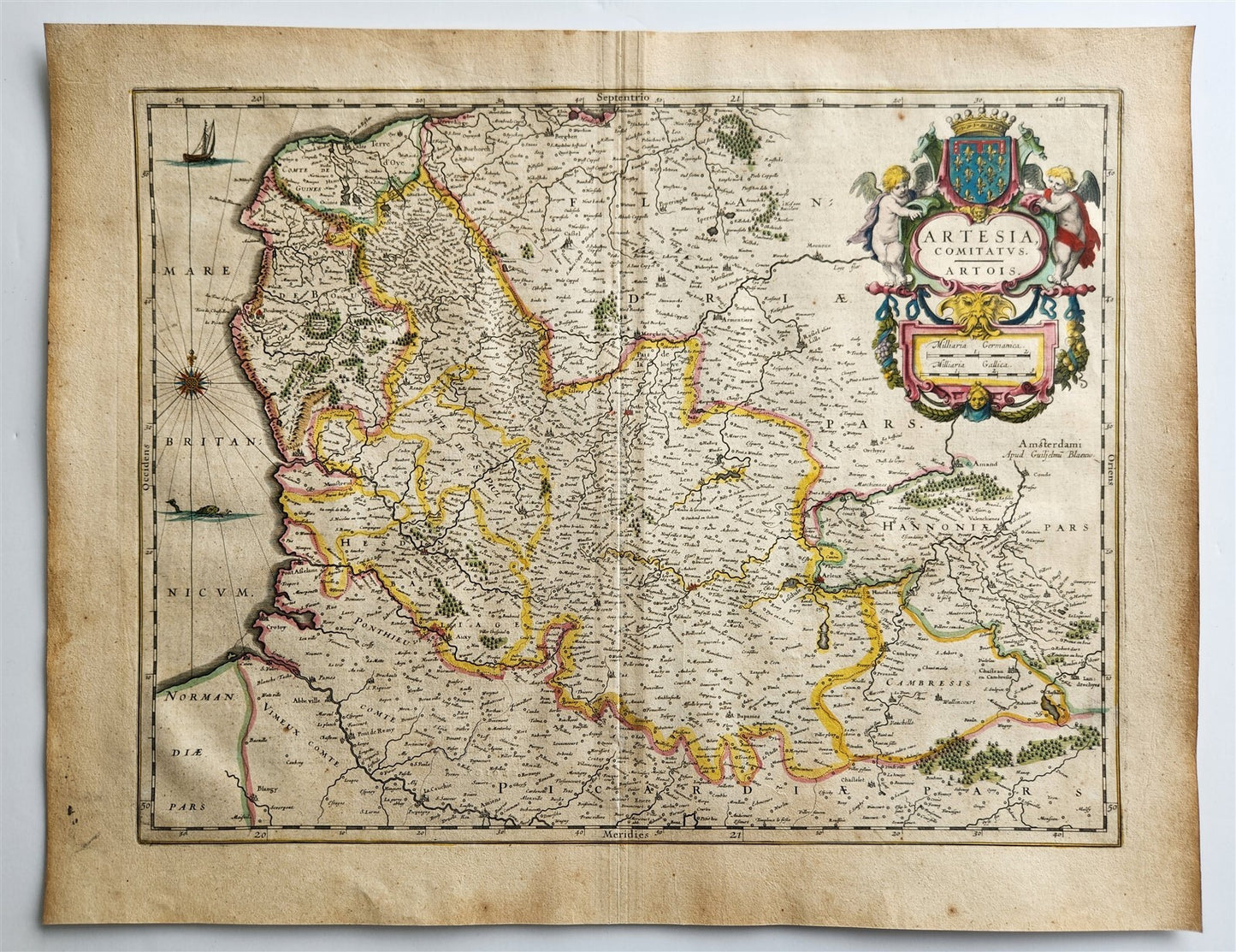
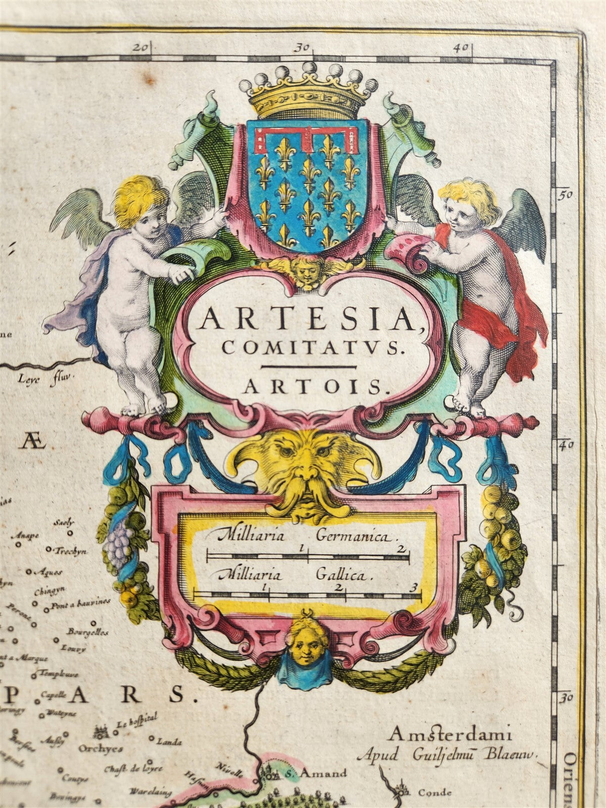
MAP ARTESIA COMITATUS (Northern France)Amsterdam: Willem Blaeu; 1640. (from : Theatrum orbis terrarum, sive Atlas novus)"Artesia Comitatus" translates to "Artesia County" or "County of Artois" in Latin. It's a historical term referring to the region of Artois in northern France. The term is often found in older maps and documents, particularly from the 17th century, depicting the area of Artois. "Comitatus" itself is a Latin word meaning "county" or "retinue," and was used to denote administrative divisions in various regions, including Germanic and Roman areas. Hand coloredOverall 18 by 22.5 inchesVery good condition100% authentic=========================================Please see my other auctions Thank You
Refund Policy: We will issue a FULL REFUND, 100% money back if you are not satisfied with your purchase. Items must be returned to us within 20 days in order to receive a refund or replacement. Buyer is responsible for shipping costs.
-----------------------------------------------------------------------------------------------------------------------------------------------------------------------------------------------------------------------------------------------------------------------------------------------------------------------------------------------------------------------------------------------------------------------------------------------------------------------------------------------------------------------------------------------------------------------------------------------------------------------------------------------------------------------------------------------------------------------------------------------------------------------------------------------------------------------------------------------------------------------------------------------------------------------------------------------------------------------------------------------------------------------
MAP ARTESIA COMITATUS (Northern France)Amsterdam: Willem Blaeu; 1640. (from : Theatrum orbis terrarum, sive Atlas novus)"Artesia Comitatus" translates to "Artesia County" or "County of Artois" in Latin. It's a historical term referring to the region of Artois in northern France. The term is often found in older maps and documents, particularly from the 17th century, depicting the area of Artois. "Comitatus" itself is a Latin word meaning "county" or "retinue," and was used to denote administrative divisions in various regions, including Germanic and Roman areas. Hand coloredOverall 18 by 22.5 inchesVery good condition100% authentic
----------------------------------------------------------------------------------------------------------------------------------------------------------------------------------------------------------------------------------------------------------------------------------------------------------------------------------------------------------------------------------------------------------------------------------------------------------------------------------------------------------------------------------------------------------------------------------------------------------------------------------------------------------------------------------------
MAP
ARTESIA COMITATUS (Northern France)
Amsterdam: Willem Blaeu; 1640.
(from : Theatrum orbis terrarum, sive Atlas novus)
"Artesia Comitatus" translates to "Artesia County" or "County of Artois" in Latin.
It's a historical term referring to the region of Artois in northern France. The term is often found in older maps and documents, particularly from the 17th century, depicting the area of Artois.
"Comitatus" itself is a Latin word meaning "county" or "retinue," and was used to denote administrative divisions in various regions, including Germanic and Roman areas.
Hand colored
Overall 18 by 22.5 inches
Very good condition
100% authentic
=========================================
Please see my other auctions
Thank You
Refund Policy: We will issue a FULL REFUND, 100% money back if you are not satisfied with your purchase. Items must be returned to us within 20 days in order to receive a refund or replacement. Buyer is responsible for shipping costs.
Powered by SixBit's eCommerce Solution
View full details
- Country/Region:France
- Date Range:1600-1699
- Type:Topographical Map