Motka
1640 MAP of GERMANY CLEVE & RAVENSTEIN by WILLEM BLAEU antique AUTHENTIC
1640 MAP of GERMANY CLEVE & RAVENSTEIN by WILLEM BLAEU antique AUTHENTIC
Regular price
$150.50 USD
Regular price
$215.00 USD
Sale price
$150.50 USD
Unit price
per
Couldn't load pickup availability
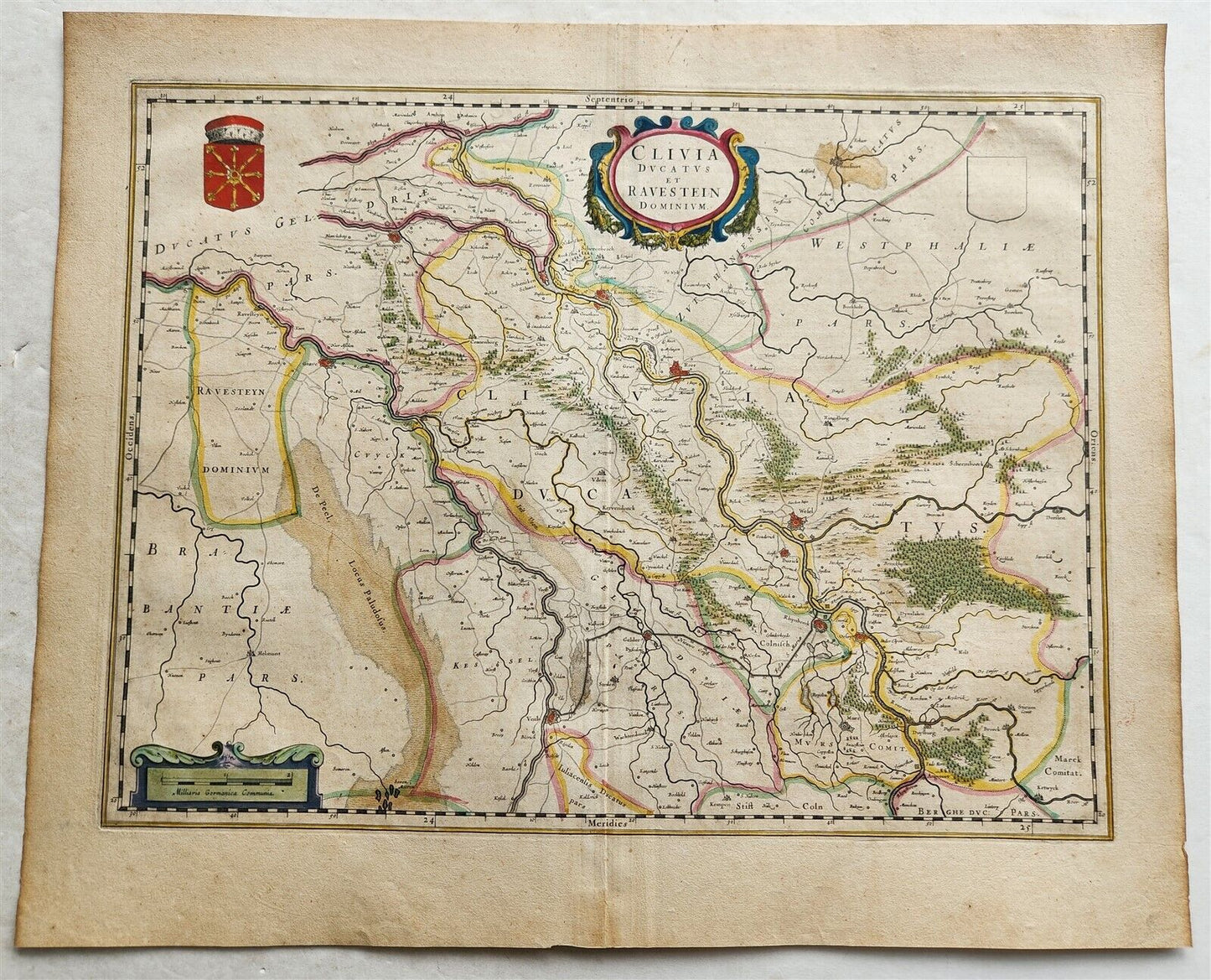
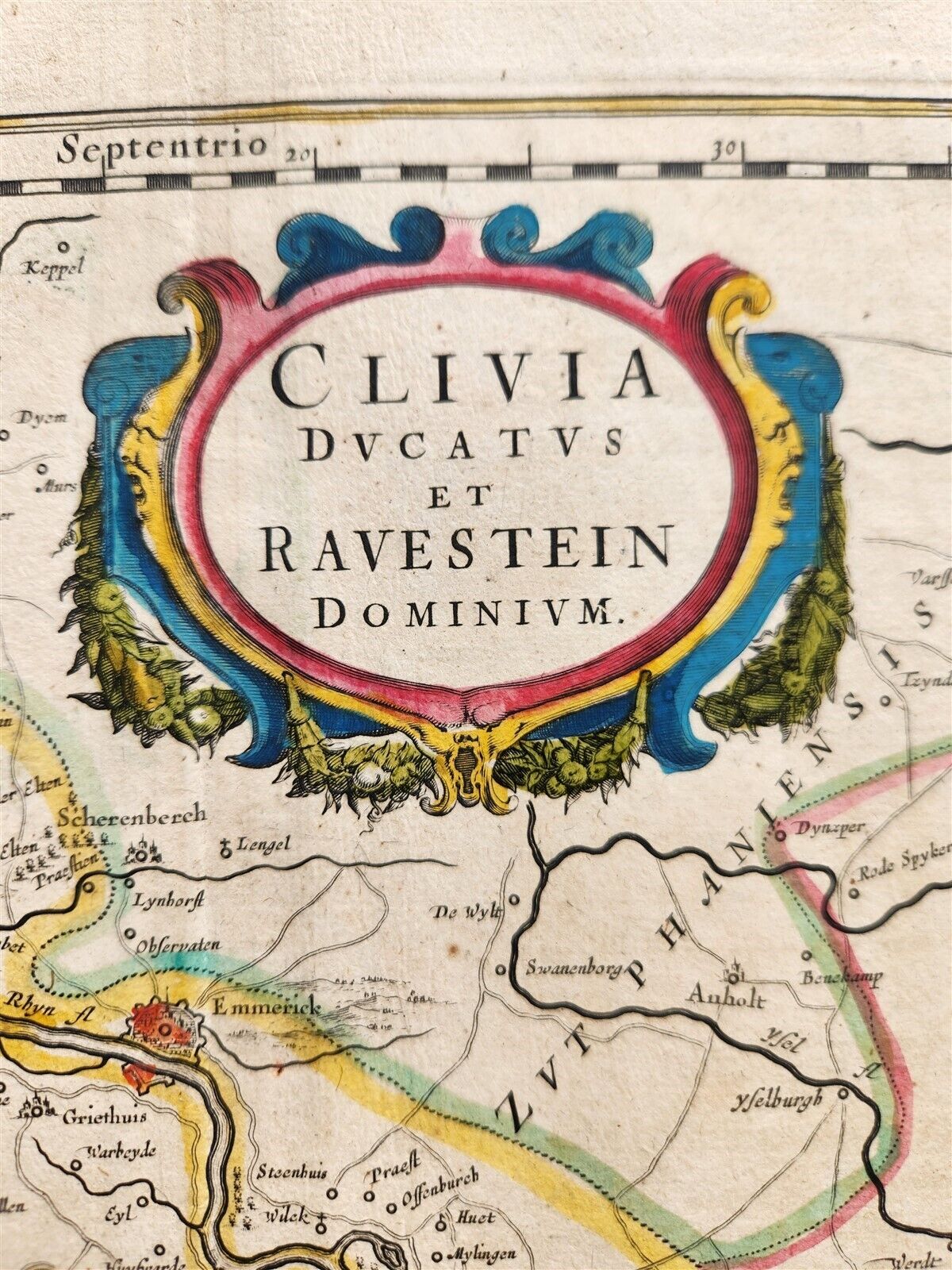
MAP CLIVIA DUCATUS et RAVENSTEIN DOMINIUMAmsterdam: Willem Blaeu; 1640. (from : Theatrum orbis terrarum, sive Atlas novus)Map of Germany :Duchy of Cleve and Dominion of Ravenstein.Shows the course of the Rhine as it flows from Germany toward Gelderland. Larger cities include Emmerick, Wesel and Kleve.Plate size 14 3/4 by 19 1/2 inches (overall 18 1/2 by 22 1/2 inches)Hand coloredVery good condition100% authentic=========================================Please see my other auctions Thank You
Refund Policy: We will issue a FULL REFUND, 100% money back if you are not satisfied with your purchase. Items must be returned to us within 20 days in order to receive a refund or replacement. Buyer is responsible for shipping costs.
------------------------------------------------------------------------------------------------------------------------------------------------------------------------------------------------------------------------------------------------------------------------------------------------------------------------------------------------------------------------------------------------------------------------------------------------------------------------------------------------------------------------------------------------------------------------------------------------------------------------------------------------------------------------------------------------------------------------------------------------------------------------------
MAP CLIVIA DUCATUS et RAVENSTEIN DOMINIUMAmsterdam: Willem Blaeu; 1640. (from : Theatrum orbis terrarum, sive Atlas novus)Map of Germany :Duchy of Cleve and Dominion of Ravenstein.Shows the course of the Rhine as it flows from Germany toward Gelderland. Larger cities include Emmerick, Wesel and Kleve.Plate size 14 3/4 by 19 1/2 inches (overall 18 1/2 by 22 1/2 inches)Hand coloredVery good condition100% authentic
-----------------------------------------------------------------------------------------------------------------------------------------------------------------------------------------------------------------------------------------------------------------------------------------------------------------------------------------------------------------------------------------------------------------------------------------------
MAP
CLIVIA DUCATUS et RAVENSTEIN DOMINIUM
Amsterdam: Willem Blaeu; 1640.
(from : Theatrum orbis terrarum, sive Atlas novus)
Map of Germany :
Duchy of Cleve and Dominion of Ravenstein.
Shows the course of the Rhine as it flows from Germany toward Gelderland. Larger cities include Emmerick, Wesel and Kleve.
Plate size 14 3/4 by 19 1/2 inches (overall 18 1/2 by 22 1/2 inches)
Hand colored
Very good condition
100% authentic
=========================================
Please see my other auctions
Thank You
Refund Policy: We will issue a FULL REFUND, 100% money back if you are not satisfied with your purchase. Items must be returned to us within 20 days in order to receive a refund or replacement. Buyer is responsible for shipping costs.
Powered by SixBit's eCommerce Solution
View full details
- Country/Region:Germany
- Date Range:1600-1699
- Type:Topographical Map